Chapter 01 : The Concept Of Map
| Introduction The landscape of the earth's surface varies from one area to another. Normally, it is difficult to understand the landscape of a place without visiting a specific location. The map is a guide that simplifies learning about a certain area on the earth's surface without having a physical visit to the place. In this chapter, you will learn about the meaning of a map, the types of maps, the essential elements of maps, the characteristics of a good map, and the importance of maps. The competencies developed will enable you to elaborate types of the maps in different contexts. |
| Think The layout of different places on the earth's surface |
Meaning of a map
A map is a drawing that represents the information found on the earth's surface by using a specific scale. Maps can be drawn on a paper, a piece of cloth, digital, or any flat area. The geographical information that can be represented on a map includes mountains, valleys, rivers, roads, buildings, and other important information. Maps help us to understand places and how to access them.
1. Why do we need maps?
2. Explain the difference between a picture and a map.
Types of maps
Different criteria are used to identify the types of maps. One of the criteria is the purpose of the map. By using this criterion, there are two types of maps namely; general maps and thematic maps.
General maps
These are maps that provide general information about a certain area. These maps do not present just one piece of information but offer various details about the area. For example: they can include information about roads, rivers, administrative boundaries, settlements, mountains, and vegetation. These maps help the user to understand the basic information about a place, the relationship between different features presented on the map, and to identify directions on the earth's surface. Therefore, general maps include: topographical maps, political maps. and road and railway maps.
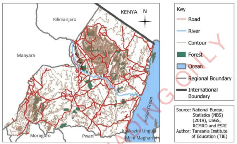
Topographical maps
These maps represent the layout of natural and man-made features on the earth's surface. Also. topographical map use contour line to show the terrain of an area. Example of natural features include: ocean, lakes, rivers, plains, valleys, mountains, and vegetation. Example of man-made features include buildings, and roads. as shown in Figure 1. These maps are important in planning for construction, tourism, farming, industries, fishing, and business activities.
| Topographical Map Of Tanga Region
Figure 01 : Topographical Map Of Tanga Region |
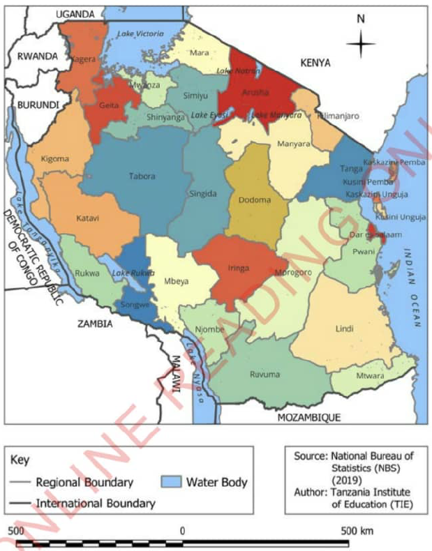
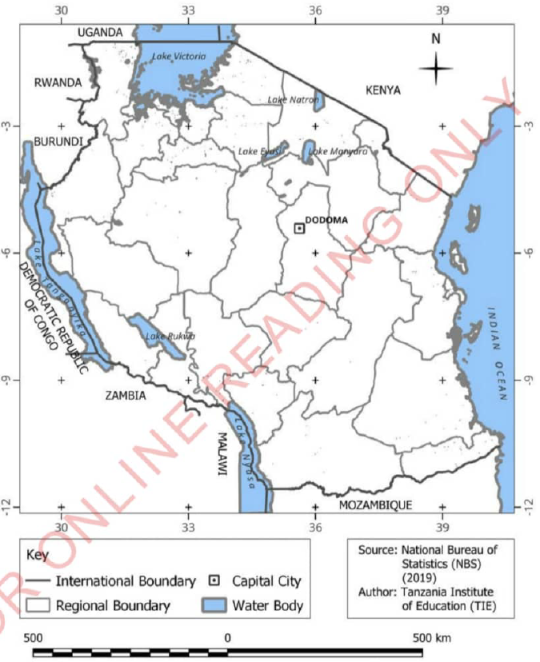
Political maps
These maps provide information about the international, regional, district and other local boundaries. They also show important areas such as government buildings, capital cities, and towns, as shown in Figure 2. Political maps are helpful for researchers, learners, and visitors who need to understand the administrative boundaries of a certain area.
Political maps change over time. Several factors can cause changes in a political map. These include wars, boundaries conflicts between countries, the nationalism, political agreements, and a boundary changes within a country. Because of these factors, political maps are updated to show the current national boundaries or other specific
| Tanzania Regional Administrative Map
Figure 02 : Regional Administrative Boundaries |
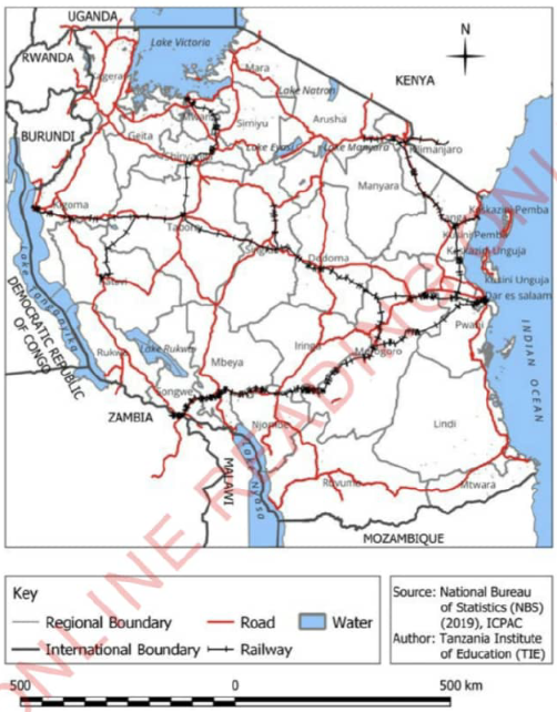
Road and railway maps
These maps provide important information about road and railway networks, such as highways and street roads, and important signs or symbols of a certain area as shown in Figure 3. They also show the distance between different locations and often provide information about petrol stations, restaurants, and hotels. Road and railway maps are important for drivers and travellers.
| Tanzania Roads And Railways Network Map
Figure 03 : Road And Railway Map |
Exercise 2
1. What type of map will you use to reach a region you have never been to?
2. Why do political maps change over time?
3. If you want to climb a mountain, what type of map would you use to understand the elevation of that mountain?
Thematic maps
These maps represent specific and unique themes or information. Thematic maps can vary depending on the theme being presented. For example. thematic maps can represent types of soils, vegetation, crops, human populations. weather, and urban planning.
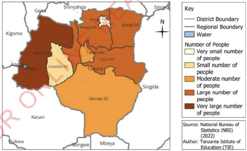
Population map
This map represents the density or distribution of people in a certain area. Population maps help us see where areas are crowded or not crowded. They are useful for people who make decisions about where to put important things like schools, hospitals, markets, and
| Tabora Population Distribution Map
Figure 04 : Population Distribution In Tabora Region |
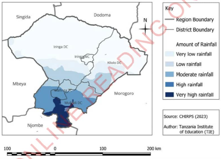
Weather maps
These maps represent the distribution of weather in a certain area. They illustrate elements of weather such as temperature, rainfall, wind, humidity, and atmospheric pressure, and how they differ from one place to another. These maps are important for farming, business, tourism, and transportation activities. Figure 5 shows rainfall distribution in Iringa region.
They illustrate elements of weather such as temperature, rainfall, wind, humidity, and atmospheric pressure, and how they differ from one place to another. These maps are important for farming, business, tourism, and transportation activities. Figure 5 shows rainfall distribution in Iringa region.
| Rainfall Distribution In Iringa Region
Figure 05 : Rainfall Distribution In Iringa Region |
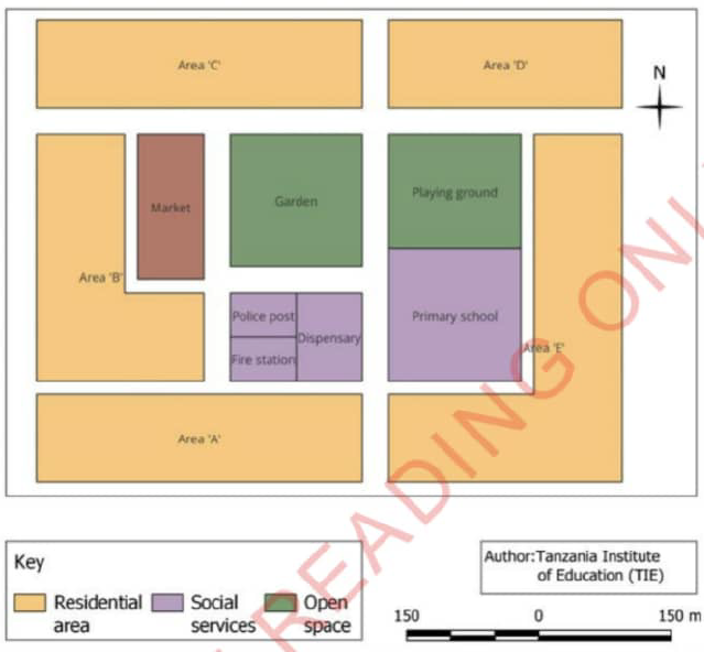
Urban planning maps
These maps show the planning of towns, cities and villages for settlement and social services. For example the placement of houses, shops, schools, hospitals. and roads as shown in Figure 6. These maps are mostly used by land surveyors and urban planning officers .
| Town Planning
Figure 06 : Urban Planning Map |
Exercise 03
1. Why thematic maps can greatly vary even if they show the same area?
2. If there is a fire emergency in your neighborhood, what type of map would you use to direct the firefighters to the area?
3. Carefully observe the following table, then suggest an appropriate map that may be used by the following people.
| No. | A person | Type of map |
| 1. | A builder | |
| 2. | A driver | |
| 3. | A tourist | |
| 4. | A Farmer |
| Activity 01 : Observe figure 07 then answer the following questions
Figure 07 : Types Of Map |
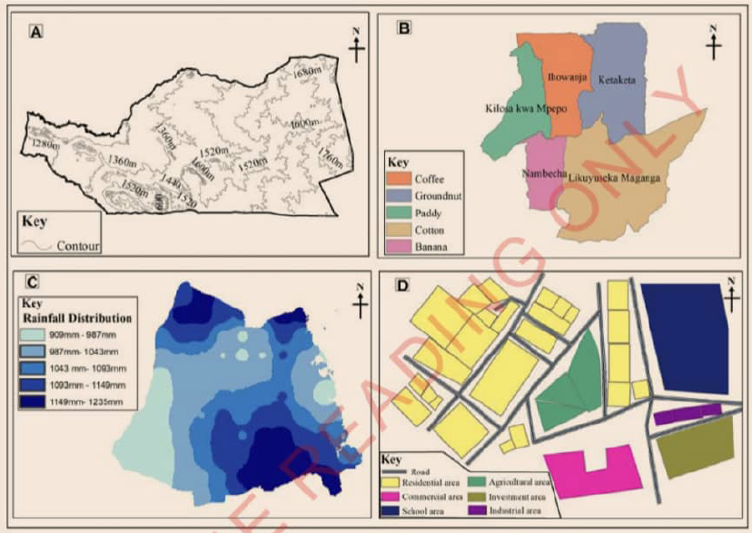
1. Identify the type of maps in A, B, C, and D as presented in Figure 7.
2. Identify thematic maps and general maps shown in Figure 7.
Essential elements of a map
The essential elements of a map are the basic parts that help in the use of a specific map. These elements give the map its meaning and make it accurate. They help to make the map easier to understand and present information about the place correctly. Here are the essential elements that should be included on a map.
(a) Frame: a border or outer line surrounding the map. The map frame helps to clearly define the map's boundaries and separates it from other information on the page. It shows where the map begins and ends;
(b) Title: helps to introduce a map to the users by identifies what a map is about or the geographical information or features it represents. For example, if the map shows roads in Tanzania, the title of the map might be 'Tanzania's roads map;
(c) North Direction: it indicates the direction on the map. It is usually represented by a North arrow. This element helps the reader to identify other directions such as South, East, and West. Knowing directions on a map helps you to understand where things are located; O
(d) Key: it explains the signs and symbols used on a map. For example, a symbol of a tree might represent a forest, and a blue wavy line might represent a river;
(e) Scale: it shows the relationship between the distance on a map and the real distance on the ground. For example. one centimetre on the map might represent ten kilometres on the ground;
(f) Grid Lines: these are lines that divide a map into squares. They help to locate specific areas on the map. Each square has a n umber or letter to help you find things easily; and
(g) Source: it shows where the information presented on a map was obtained. The source can be a government organisation, a non-government organisation, or an individual. Showing the source of the map helps verify its accuracy and allows other users to refer to it in their work. Figure 8 shows the essentials of a map.
| Map Of Tanzania
Figure 08 : Essential Elements Of Map |
| Activity 02 : Observe figure 09 then answer questions that follows
Figure 09 : Mwendapole Village |
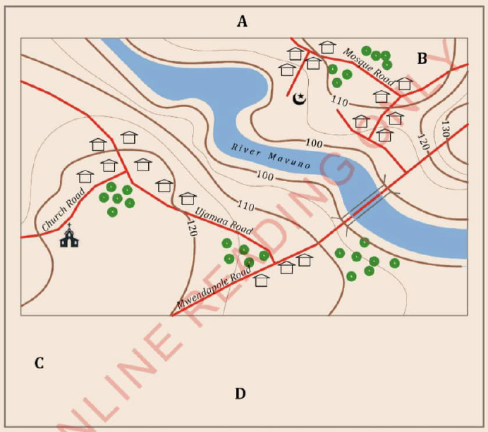
QUESTION
1.Explain the weaknesses you have identified in Figure 9.
2.Identify the essentials of a map that should be placed at points A, B, C and D, then explain the importance of each element you have identified.
3. Identify the type of maps represented by Figure 9
Characteristics of good maps
A good map should have the following characteristics:
(a) It should be easy to read and interpret;
(b) it should include all the essential elements of a map, such as scale, frame, source, key, grid lines, title, and North direction;
(c) it should represent the actual places, and distances, as well as place objects correctly;
(d) it should use clear colours and neat writing to help users understand it better;
(e) it should only show the information that is needed for specific purpose;
(f) it should use the same symbols, colours, and styles consistently across the map for easy understanding; and
(g) it should have the up to date information so that everything shown is correct.
Importance of maps
A map is like a guidebook for the world, helping us learning by explore, and understand the places around us. Therefore, a map is an important tool used by people in various contexts. The following are some key reasons for using maps:
(a) To find and learn about places, even if we have never been there before;
(b) to know distances from one place to another;
(c) to know the right direction to take to reach our destination, such as North, South, East. or West;
(d) to plan our travels by showing the best roads, shortcuts, and interesting places we might see along the way;
(e) to understand different features in our environment, such as mountains, rivers, lakes, and forests;
(f) to help during emergencies like fires and floods by guiding people;
(g) to learn about the weather in different places by showing rainfall distribution, vegetation cover, and human activities;
(h) to show where important resources in our country are found, such as rivers, lakes, forests, and minerals;
(i) to show where people live and how many people are in different areas; and
(j) to know administrative boundaries, such as international, regional, district, and village boundaries;
(k) to show tourist attractions such as Mount Kilimanjaro, the Ngorongoro Crater, and wildlife reserves These help in attracting tourists to visit these places; and
(I) to understand the history of a place by showing how it has changed over time.
Exercise 02
1. How do maps assist in promoting tourism activities?
2. How can a farmer use a map?
Vocabulary
Compass : a tool used to show direction, with an arrow pointing North at all times
Consistency : maintaining the same symbols and colours that represent the same thing on a map
Landscape : the way the land looks
Man-made features : things built by people
Physical visit : going to see a place in person
Population density : how many people live in a certain area
Surveyor : a person who measures land to help decide where things like buildings and roads should be placed
Urban planning : how cities and towns are designed and arranged
www.learninghubtz.co.tz
Revision exercise
Section: A: Choose the letter of the correct answer.
I. What is a map?
- Representation of features of the earth's surface using the North direction.
- Representation of features of the earth's surface using a scale.
- Representation of features of the earth's surface using a key.
- Representation of features of the earth's surface using grid lines.
2. Which of these maps show natural and man-made features?
- Topographical maps.
- Political maps.
- Economic maps.
- Thematic maps.
3. Which of the following is one of the characteristics of a good map?
- Having many colours.
- Having many attractive symbols.
- Being readable and easy to interpret.
- Having many scientific terms.
4. What is the importance of maps to human life?
- Gaining expertise.
- Helping to show various symbols used in a map.
- Showing where important national resources are located.
- Demonstrating the ability to draw maps.
5. How can maps assist during emergencies?
- Showing how a fire is spreading.
- Indicating how disasters occur.
- Helping rescue teams to determine the right direction to the area.
- Assisting rescue teams in extinguishing the fire.
6. How can maps help resolve land conflicts?
- By showing the distribution of people.
- By showing administrative boundaries.
- By showing the direction of places.
- By showing distances between locations.
7. How can maps be a source of government revenue?
- Guiding to the tourist attractions.
- Showing areas with modern roads.
- Helping people access healthcare services.
- Showing areas for celebrations and entertainment.
Section: B: Matching items
8. Match the items in column A with those in column B to produce a meaningful statement
| Column A | Column B |
|
|
Section: C: Short answer items:
9. What are the qualities of a good map? List them by giving examples.
10. In what ways do topographical maps differ from urban plan maps?

Hub App
 For Call,Sms&WhatsApp: 255769929722 / 255754805256
For Call,Sms&WhatsApp: 255769929722 / 255754805256  RATIBA NECTA KIDATO CHA IV 2026
Matokeo Darasa VII 2025
Matokeo KIDATO CHA II 2024
Matokeo Darasa IV 2024
SECONDARY REGIONAL EXAMS
PRIMARY REGIONAL EXAMS
FORM VI NECTA REVIEWS
FORM IV NECTA REVIEWS
FORM II NECTA REVIEWS
STD VII NECTA REVIEWS
STD IV NECTA REVIEWS
SECONDARY EXAMS SERIES
PRIMARY EXAMS SERIES
PRIMARY SUBJECT NOTES
SECONDARY SUBJECT NOTES
SECONDARY TOPICAL EXAMS
SECONDARY TOPICAL QUESTIONS
PRIMARY TOPICAL QUESTIONS
PRACTICAL EXAMS & NOTES
SECONDARY REGIONAL EXAMS
DOWNLOAD SUBJECT NOTES
SCHEMES OF WORK (PRIMARY & SECONDARY)
LESSON PLAN
SECONDARY LOG BOOKS
PRIMARY LOG BOOKS
LITERARY WORKS / UCHAMBUZI VITABU
METHALI ZOTE ZA KISWAHILI
Vitendawili Vya Kiswahili
FORM VI RESULTS 2024
FORM FIVE SELECTION 2024
MATOKEO KIDATO CHA IV 2023
FORM ONE SELECTION 2024
FORM VI RESULTS 2023
Matokeo Darasa IV 2022
RATIBA NECTA KIDATO CHA IV 2026
Matokeo Darasa VII 2025
Matokeo KIDATO CHA II 2024
Matokeo Darasa IV 2024
SECONDARY REGIONAL EXAMS
PRIMARY REGIONAL EXAMS
FORM VI NECTA REVIEWS
FORM IV NECTA REVIEWS
FORM II NECTA REVIEWS
STD VII NECTA REVIEWS
STD IV NECTA REVIEWS
SECONDARY EXAMS SERIES
PRIMARY EXAMS SERIES
PRIMARY SUBJECT NOTES
SECONDARY SUBJECT NOTES
SECONDARY TOPICAL EXAMS
SECONDARY TOPICAL QUESTIONS
PRIMARY TOPICAL QUESTIONS
PRACTICAL EXAMS & NOTES
SECONDARY REGIONAL EXAMS
DOWNLOAD SUBJECT NOTES
SCHEMES OF WORK (PRIMARY & SECONDARY)
LESSON PLAN
SECONDARY LOG BOOKS
PRIMARY LOG BOOKS
LITERARY WORKS / UCHAMBUZI VITABU
METHALI ZOTE ZA KISWAHILI
Vitendawili Vya Kiswahili
FORM VI RESULTS 2024
FORM FIVE SELECTION 2024
MATOKEO KIDATO CHA IV 2023
FORM ONE SELECTION 2024
FORM VI RESULTS 2023
Matokeo Darasa IV 2022
WHATSAPP US NOW FOR ANY QUERY
App Ya Learning Hub Tanzania