?> GEOGRAPHY STANDARD FOUR EXAMS SERIES
GEOGRAPHY STANDARD FOUR EXAMS SERIES

Pupil’s name: _______________________________________
School name: ___________________________________________

PRIME MINISTER’S OFFICE, REGIONAL ADMINISTRATIVE AND LOCAL GOVERNMENT

TERMINAL EXAMINATION FOR STD FIVE 2026

SUBJECT- GEOGRAPHY AND ENVIRONMENT 

SECTION A: GEOGRAPHY AND ENVIRONMENT (26MARKS)

Answer all questions in this section.

1. For each of the items (i) – (xv), choose the correct answer and write its letter in the box provided: 

i. Which of the following is not classify as a natural resource in the vegetable farming projects?

  1. Land 
  2. water
  3. labour 
  4. seed 
  5. minerals

ii. Which resource directly enables the actual growth of vegetable crops?

  1. Money 
  2. machinery 
  3. seeds 
  4. labour 
  5. storage facilities

iii. A community in Tanzania wants to develop a sustainable income source from their local forest. Which forest-related activity would best provide income while preserving the forest’s environmental functions?

  1. Clear-cutting all trees for timber scale 
  2. Establishing a beekeeping project in the forest
  3. Converting the forest into agricultural farmland 
  4. Mining minerals inside the forest area
  5. Using the forest only for firewood collection without replanting

iv. The Tanzania National Parks Authority (TANAPA) needs to decide which action will most effectively protect the “big five” wildlife in a national park. Which management action is most appropriate?

  1. Allowing unrestricted tourist hunting of big five 
  2. Expanding agricultural zones inside the park
  3. Creating stricter anti-poaching patrols and habitat protection 
  4. Relocating the big five to private farms 
  5. Reducing the park’s protected area size

v. Some children have a tendency of defecating and urinating in water sources. What is the effects of that act?

  1. Increase of fish 
  2. Increase of water 
  3. spread of diseases 
  4. purify water 
  5. treat water

vi. Mr. Njate climbed Mount Kilimanjaro and reached the summit after three days. What did he see on the top of the Mountain?

  1. Ocean and dam 
  2. Manmade snow 
  3. Stone’s house only 
  4. Snow 
  5. accumulation of mud

2. Answer items (i) – (v) by matching the location of the national parks found in Tanzania in List A with their name in List B and write the letter of the correct response in the bracket provided.

LIST A

Answer

LIST B

i. North-western (Mara, Arusha, Simiyu)


A. Serengeti

B. Tarangire

C. Kondoa Irangi

D. Lake Manyara

E. Ngorongoro

F. Ruaha

G. Gombe

ii. Northern (Manyara, Arusha, Dodoma?


iii. Northern ( Arusha and Manyara)


iv. Southern western (Iringa and Mbeya)


3. i. What is the contribution of Gold to Tanzania economy ?

  1. _______________________________________
  2. _______________________________________

ii. Tanzania is also rich in renewable resources. Mention any two renewables resources.

  1. _______________________________________
  2. __________________________________

iii. To promote the blue economy sector, what sustainable use of resources should we focus on?

  1. ________________________________________
  2. ______________________________

4.Study the following map and then answer question (a) – (d) by writing the correct answer in the space provided.

A MAP OF MSANGALALE WARD

  image 


Questions:

a) How many mountains are there on map above?

________________________________________________________

b) Name any two man- made features shown on the map.

i) _______________________________________

ii) _________________________________________

c) What is the direction of the mosque from the church?

_________________________________________________________

d) How many bridges are there on the map above?

_________________________________________________________

e) What symbol from the map stand for the natural feature of the mountain? Draw the symbol.

__________________________________________________________

SECTION B: SPORT AND ARTS ( 24MARKS)

5. Choose the correct answer and write its letter in the box provided.

 i. The following are drawing tools except

A: Duster B: A water C: A pencil D: Table and chair 

ii. Which types of performing art is popular with pupils?. 

(A)Story telling (B)music (C) Recitation (D) Modelling

iii. What is the name of the clothes used by actors during performances? 

(A) Costume(B) Make up (C) Materials (d) clothes

iv .________is the art of portraying a character is a story or on a stage. 

(A) praying ( B) Acting (C) Running (D) Jumping

6. Match the items in list A against those in list B by writing the letter of the correct sentences beside the item number.


COLUMN A


COLUMN B

I

Rattle


A. Struck instruments

B. Cup

C. Kayamba

D. Flute

F. A traditional game played by two people using small seeds or shells

G. A game that is played by using hands by tree people

H. Percussion instrument

Ii

Drum


iii

Bao


iv

Wind instruments


v.

Rede


7. (a) Mention two main things to consider when acting out with actions and sound.  

(i)_________________________________________ 

(ii)_________________________________________

b.The children seen in the picture below are actors preparing to perform.


image  

 QUESTIONS 

i. What are people who do performing arts called? __________________________  

ii. What is that play called?._____________________________________________

iii. What are the clothes they are wearing called? ___________________________________

LEARNINGHUBTZ.CO.TZGEOGRAPHY STANDARD FOUR EXAM SERIES 131

OFFICE OF THE PRESIDENT, REGIONAL ADMINISTRATION AND LOCAL  GOVERNMENT
PRIMARY EXAMINATION TERMINAL STANDARD FOUR
GEOGRAPHY 
TIME: 1:30 Hrs  MAY, 2025
SECTION A
1.  MULTIPLE CHOICE 
i. What is a map 
(A) representation of features of the earths surface using the north direction 
(B) representation of features of the earths surface using a scale on a piece of paper. 
(C) representation of features of the earths surface using a scale 
(D) representation of features of the earths surface using grid lines 
ii. Which of these maps show natural and man — made features? 
(A) topographical maps 
(B) political maps 
(C) economic maps 
(D) thematic maps 
iii. Which of the following is one of the characteristics of a good map
(A) having many colours 
(B) having many attractive symbols 
(C) being readable and easy to interpret 
(D) having many scientific terms 
iv. What is the importance of maps to human life? 
(A) gaining expertise
(B) helping to show various symbols used in a map? 
(C) showing where important national resources are located 
(D) demonstrating the ability to draw maps 
v. How can maps assist during emergencies? 
(A) showing how a fire is spreading 
(B) indicating how disasters occurs 
(C) helping rescue teams to determine the right direction to the area 
(D) assisting rescue teams in extinguishing the fire 
2. 
i. How can maps help resolve land conflicts? 
(A) by showing the distribution of people 
(B) by showing administrative boundaries 
(C) by showing the direction of places 
(D) by showing distances between locations 
ii. How can maps be a source of government revenue? 
(A) guiding to the tourist attractions 
(B) showing areas with modern roads 
(C) helping people access health care services 
(D) showing areas of celebrations and entertainment 
iii. What is the main purpose of a map? 
(A) to show how to make a drawing 
(B) to show the location of features on the earths surface 
(C) to show how to calculate distances 
(D) to show rescue methods 
iv.   Which   essential   element   of   a   map   can   be   used   to   determine   the   actual   distance   on  the ground 
(A) key
(B) scale 
(C) title 
(D) gridlines 
v.   Which   of   the   following   essential   elements   of   a   map   will   tell   you.   What   is   the   map  about? 
(A) scale 
(B) margin 
(C) legend 
(D) title 
3. 
i. Cartographers use all of the following symbols to represent features in a map except 
(A) colours 
(B) letters 
(C) signs 
(D) trees 
ii. How will you know that a map given to you is a statistical map? 
(A) it represents mountains 
(B) it shows rivers 
(C) it represent mountains 
(D) it represent rainfall data 
(E) it has many man- made features 
iii. What features on the land surface is represented by this sign in a map? 
(A) Railway 
(B) telephone line 
(C) railway station 
(D) railway crossing 
iv.   Salim   failed   to   tell   the   correct   directions   of   features   in   a   given   map.   What   essential   of  a map was certainly missing in that map? 
(A) north direction 
(B) map scale 
(C) key 
(D) title 
v. Which direction does a compass arrow usually point? 
(A) north 
(B) south 
(C) eat 
(D) west 
4.  SECTION B: MATCHING ITEMS


Read the following passage and the questions that follow 
Map symbols

A   map   cannot   show   things   exactly   as   they   are   in   reality   instead,   it   uses   map   symbols.  Map   symbols   are   small   drawings   used   on   a   map   to   represent   real   objects.   When   you  want   to   show   real   objects   on   a   map,   you   should   use   symbols   to   represent   those   objects.  These   symbols   help   to   describe   those   features   simply   and   understandably.   All   symbols  used on a map are shown in the map key. Which explains all the symbols used. 
5.  QUESTIONS 
i. What is the heading of the passage ...................................
ii. What do we call the small drawings on a map that represents real objects ................... 
iii. All symbols used on a map are shown in a ...................................
iv. Mention any two physical features that can be shown on a map and ...........................
v. Mention any two man- made features that can be shown on a map and ...........................

LEARNINGHUBTZ.CO.TZGEOGRAPHY STANDARD FOUR EXAM SERIES 118

OFFICE OF THE PRESIDENT, REGIONAL ADMINISTRATION AND LOCAL  GOVERNMENT
PRIMARY EXAMINATION TERMINAL STANDARD FOUR
GEOGRAPHY 
TIME: 1:30 Hrs  MAY, 2025
SECTION A
1.  MULTIPLE CHOICE 
i. What is a map 
(A) representation of features of the earths surface using the north direction 
(B) representation of features of the earths surface using a scale on a piece of paper. 
(C) representation of features of the earths surface using a scale 
(D) representation of features of the earths surface using grid lines 
ii. Which of these maps show natural and man — made features? 
(A) topographical maps 
(B) political maps 
(C) economic maps 
(D) thematic maps 
iii. Which of the following is one of the characteristics of a good map
(A) having many colours 
(B) having many attractive symbols 
(C) being readable and easy to interpret 
(D) having many scientific terms 
iv. What is the importance of maps to human life? 
(A) gaining expertise
(B) helping to show various symbols used in a map? 
(C) showing where important national resources are located 
(D) demonstrating the ability to draw maps 
v. How can maps assist during emergencies? 
(A) showing how a fire is spreading 
(B) indicating how disasters occurs 
(C) helping rescue teams to determine the right direction to the area 
(D) assisting rescue teams in extinguishing the fire 
2. 
i. How can maps help resolve land conflicts? 
(A) by showing the distribution of people 
(B) by showing administrative boundaries 
(C) by showing the direction of places 
(D) by showing distances between locations 
ii. How can maps be a source of government revenue? 
(A) guiding to the tourist attractions 
(B) showing areas with modern roads 
(C) helping people access health care services 
(D) showing areas of celebrations and entertainment 
iii. What is the main purpose of a map? 
(A) to show how to make a drawing 
(B) to show the location of features on the earths surface 
(C) to show how to calculate distances 
(D) to show rescue methods 
iv.   Which   essential   element   of   a   map   can   be   used   to   determine   the   actual   distance   on  the ground 
(A) key
(B) scale 
(C) title 
(D) gridlines 
v.   Which   of   the   following   essential   elements   of   a   map   will   tell   you.   What   is   the   map  about? 
(A) scale 
(B) margin 
(C) legend 
(D) title 
3. 
i. Cartographers use all of the following symbols to represent features in a map except 
(A) colours 
(B) letters 
(C) signs 
(D) trees 
ii. How will you know that a map given to you is a statistical map? 
(A) it represents mountains 
(B) it shows rivers 
(C) it represent mountains 
(D) it represent rainfall data 
(E) it has many man- made features 
iii. What features on the land surface is represented by this sign in a map? 
(A) Railway 
(B) telephone line 
(C) railway station 
(D) railway crossing 
iv.   Salim   failed   to   tell   the   correct   directions   of   features   in   a   given   map.   What   essential   of  a map was certainly missing in that map? 
(A) north direction 
(B) map scale 
(C) key 
(D) title 
v. Which direction does a compass arrow usually point? 
(A) north 
(B) south 
(C) eat 
(D) west 
4.  SECTION B: MATCHING ITEMS


Read the following passage and the questions that follow 
Map symbols

A   map   cannot   show   things   exactly   as   they   are   in   reality   instead,   it   uses   map   symbols.  Map   symbols   are   small   drawings   used   on   a   map   to   represent   real   objects.   When   you  want   to   show   real   objects   on   a   map,   you   should   use   symbols   to   represent   those   objects.  These   symbols   help   to   describe   those   features   simply   and   understandably.   All   symbols  used on a map are shown in the map key. Which explains all the symbols used. 
5.  QUESTIONS 
i. What is the heading of the passage ...................................
ii. What do we call the small drawings on a map that represents real objects ................... 
iii. All symbols used on a map are shown in a ...................................
iv. Mention any two physical features that can be shown on a map and ...........................
v. Mention any two man- made features that can be shown on a map and ...........................

LEARNINGHUBTZ.CO.TZGEOGRAPHY STANDARD FOUR EXAM SERIES 117

OFFICE OF THE PRESIDENT, REGIONAL ADMINISTRATION AND LOCAL  GOVERNMENT
PRIMARY EXAMINATION TERMINAL STANDARD FOUR
GEOGRAPHY 
TIME: 1:30 Hrs  MAY, 2025
SECTION A
1.  MULTIPLE CHOICE 
i. What is a map 
(A) representation of features of the earths surface using the north direction 
(B) representation of features of the earths surface using a scale on a piece of paper. 
(C) representation of features of the earths surface using a scale 
(D) representation of features of the earths surface using grid lines 
ii. Which of these maps show natural and man — made features? 
(A) topographical maps 
(B) political maps 
(C) economic maps 
(D) thematic maps 
iii. Which of the following is one of the characteristics of a good map
(A) having many colours 
(B) having many attractive symbols 
(C) being readable and easy to interpret 
(D) having many scientific terms 
iv. What is the importance of maps to human life? 
(A) gaining expertise
(B) helping to show various symbols used in a map? 
(C) showing where important national resources are located 
(D) demonstrating the ability to draw maps 
v. How can maps assist during emergencies? 
(A) showing how a fire is spreading 
(B) indicating how disasters occurs 
(C) helping rescue teams to determine the right direction to the area 
(D) assisting rescue teams in extinguishing the fire 
2. 
i. How can maps help resolve land conflicts? 
(A) by showing the distribution of people 
(B) by showing administrative boundaries 
(C) by showing the direction of places 
(D) by showing distances between locations 
ii. How can maps be a source of government revenue? 
(A) guiding to the tourist attractions 
(B) showing areas with modern roads 
(C) helping people access health care services 
(D) showing areas of celebrations and entertainment 
iii. What is the main purpose of a map? 
(A) to show how to make a drawing 
(B) to show the location of features on the earths surface 
(C) to show how to calculate distances 
(D) to show rescue methods 
iv.   Which   essential   element   of   a   map   can   be   used   to   determine   the   actual   distance   on  the ground 
(A) key
(B) scale 
(C) title 
(D) gridlines 
v.   Which   of   the   following   essential   elements   of   a   map   will   tell   you.   What   is   the   map  about? 
(A) scale 
(B) margin 
(C) legend 
(D) title 
3. 
i. Cartographers use all of the following symbols to represent features in a map except 
(A) colours 
(B) letters 
(C) signs 
(D) trees 
ii. How will you know that a map given to you is a statistical map? 
(A) it represents mountains 
(B) it shows rivers 
(C) it represent mountains 
(D) it represent rainfall data 
(E) it has many man- made features 
iii. What features on the land surface is represented by this sign in a map? 
(A) Railway 
(B) telephone line 
(C) railway station 
(D) railway crossing 
iv.   Salim   failed   to   tell   the   correct   directions   of   features   in   a   given   map.   What   essential   of  a map was certainly missing in that map? 
(A) north direction 
(B) map scale 
(C) key 
(D) title 
v. Which direction does a compass arrow usually point? 
(A) north 
(B) south 
(C) eat 
(D) west 
4.  SECTION B: MATCHING ITEMS


Read the following passage and the questions that follow 
Map symbols

A   map   cannot   show   things   exactly   as   they   are   in   reality   instead,   it   uses   map   symbols.  Map   symbols   are   small   drawings   used   on   a   map   to   represent   real   objects.   When   you  want   to   show   real   objects   on   a   map,   you   should   use   symbols   to   represent   those   objects.  These   symbols   help   to   describe   those   features   simply   and   understandably.   All   symbols  used on a map are shown in the map key. Which explains all the symbols used. 
5.  QUESTIONS 
i. What is the heading of the passage ...................................
ii. What do we call the small drawings on a map that represents real objects ................... 
iii. All symbols used on a map are shown in a ...................................
iv. Mention any two physical features that can be shown on a map and ...........................
v. Mention any two man- made features that can be shown on a map and ...........................

LEARNINGHUBTZ.CO.TZGEOGRAPHY STANDARD FOUR EXAM SERIES 116

OFFICE OF THE PRESIDENT, REGIONAL ADMINISTRATION AND LOCAL GOVERNMENT

PRIMARY EXAMINATION SERIES

MARCH 2025

STANDARD FOUR, GEOGRAPHY AND ENVIRONMENT


  1. MULTIPLE CHOICES
  1.    What does the study of geography deal with?

(A)relief features and settlements only 

(B) human activities and physical features 

(C) water bodies and plants only 

(D) everything on the land

  1.  Juma lives near lake Victoria which economic activity is he likely to practise

(A) agriculture 

(B) lumbering

(C) fishing  

(D) mining 

  1. The following are feature we study on the earth except

(A) atmosphere 

(B) land 

(C) water bodies 

(D) history 

iv. Moses lives in Mafinga Iringa, where there is a dense forests. Which economic activity is he likely to practice 

(A) fishing 

(B) lumbering 

(C) mining

 (D) construction 

v. The following are branches of Geography except 

(A) photography interpretation geography 

(B) human geography 

(C) physical Geography 

(D) practical geography 

vi. Which of the following refers to the atmospheric condition experienced over a short period, it many be an hour 

(A) weather 

(B) resources 

(C) disaster 

(D) climate 

vii. The process of cutting down trees for charcoal, timber is called 

(A) afforestation 

(B)re- a forestation 

(C) deforestation 

(D) air pollution 

viii. Mr. John works in a timber processing factory. So Mr john experiences 

(A) air pollution 

(B) noise pollution 

(C) water pollution 

(D) land pollution 

ix. The following are sources of water sources except   

(A)river 

(B) lake 

(C) building 

(D) dam 

x. People who travel to places of interest for study or leisure are called 

(A) traders 

(B) students 

(C) drivers 

(D) tourist 

xi. Which of the following is physical features 

(A) mountain 

(B) mountain 

(C) river 

(D) lake 

xii. Among the following is a man- made feature .  

(A) darn 

(B) lake 

(C) valley 

(D) river 

xiii. The tallest mountain in Tanzania is called  

(A) Mt. Meru 

(B) Mt. Oldonyo Lengai 

(C) Mt. Kilimanjaro 

(D) Mt. Uluguru 

xiv. Human residences in towns and cities are called   settlements 

(A) village 

(B) urban 

(C) commercial 

(D) rural 

xv. The extraction of minerals from the under ground is called 

(A) fishing 

(B) mining

(C) lumbering

(D) agriculture  

SECTION B:

4. MATCHING ITEMS 

LIST A

ANSWER

LIST B

  1. Shows sign and symbols used on A map


A. Compass directions

  1. Makes the map look - attractive as if it is in a box


B. Frame

  1. Tells us what the map is all about


C. Key

  1. Shows the direction on a map


D. Title

  1. Shows the relationship between the ground distance and the map distance


E. Scale


SECTION C:

STRUCTURE

5. i. What is the meaning of direction? 

ii. Define re-afforestation 

Use the compass direction below to answer questions 
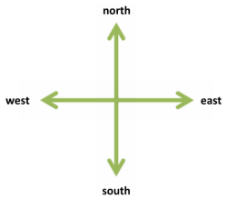
  1. Which direction does the sun set 
  2. Which direction is Mt Kilimanjaro from our school Patrick Primary school
  3.  Which direction does the sun rise 


LEARNINGHUBTZ.CO.TZGEOGRAPHY STANDARD FOUR EXAM SERIES 111

Download Learning
Hub App

For Call,Sms&WhatsApp: 255769929722 / 255754805256